Saturday 26 December 2015

Western Values Challenged Part 5 - How to fight against the elite groups

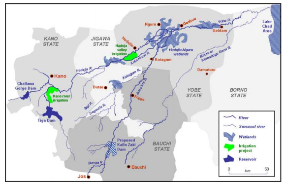
Over the last few posts, I have examined water resources management in Africa taking the Hadejia-Nguru Wetlands as an example, with the three questions being addressed. Today, I would like to consider the following final question.

3) How can we ensure the needs of small local groups/institutions will be met without their being politically hampered by the elite groups of authorities.

Photo.1 sharing water is not free of political challenges (Reference: Model UN, 2016)

The question above essentially highlights the fact that the way water is managed is often largely influenced by the national elite (Mehta et al, 2014). It is clear that they have sufficient funds to bribe other institutional groups to support their management option they raise in the course of discussion. Indeed, World Water Week (2014) once suggest that 'corruption is both a cause as well as a result of poor water governance'. In order to combat the corruption in water management, there are a number of suggestions that can be considered to be effective.

In the study undertaken by World Water Week (2014), the find that anti-corruption movement is increasingly in favour of the 'sectoral approach' to fight corruption. They argue that 'sectoral reforms can reinforce the effectiveness of general public administration and sector specific knowledge is critical to understand the risks, pressures, and resistance to reforms'. The report published by the United Nations Economic and Social Council (2006) defines the public sector reform as being 'consisting of deliberate changes to the structures and processes of public sector organizations with the objective of getting them to run better' (International Centre for Parliamentary Studies, 2012). The examples of reform include increasing integrity and transparency, and formal legislation that support transparency, and corporate governance of water utility companies (UNDP Water Governance Facility (WGF), 2015). Here, I would like to the first two examples.

In Malawi, for example, they adopted, so-called, Corruption Prevention Policy, which outlines how all stakeholders detect, report, prevent and deal with corruption and promote transparency and accountability (UNDP Water Governance Facility (WGF), 2015). This is in response to the result of the 2006 Governance and Corruption Baseline Survey which reveals that 'public institutions that are characterised by low levels of requests for gratification (bribes) include the postal service, the bureau
of standards, public health services, and water boards (Governance Baseline Survey, 2006). In fact, about half of the population (10 million) have access to water-supply facilities with only 32% of these have access to potable water across the year. The rural population is the most severely affected by the poor management so that they are mostly dependent upon unsafe gravity-piped water supply, shallow wells and boreholes (UNDP Water Governance Facility (WGF), 2015). In order to improve the quality of water regardless of the socio-economic status, the above policy is believed to help the water boards consider the equity in water supply.

In South Africa, there is a formal legislation regarding water resources management, known as 'Water Services Act No.108' in 1997 together with 'The National Water Act No.36' in 1998 (Governance Baseline Survey, 2006). The former introduces the regulatory framework for the provision of water services by local authorities whereas the latter establishes the framework for water resources management and protection by all the stakeholders being involved. The significance of this law is to promote community participation in water management with 'the objective of achieving a balance among the interests of water users, potential water users, local and provincial government and environmental interest groups (Governance Baseline Survey, 2006).

Furthermore, the Department of Water Affairs and Forestry (DWAF) runs an anti-corruption hotline
through which 'stakeholders can report unethical behaviour and wrongdoings anonymously and confidentially and steps are taken to investigate allegations and pursue necessary actions' (Governance Baseline Survey, 2006). Certainly, the combination of the inclusive water management with the anti-corruption measure greatly helps improve transparency and prevent briberies.

Despite the counter-measurement, it is argued that even with briberies being avoided, it does not necessarily mean that the voices of small local groups / institutions will be equally valued as much as those elite groups. There are a number of reasons for this. Firstly, politically less powerful local groups tend to be less educated to present their views on scientific basis, which is the most powerful tool in politics. It is known that some humanitarian NGOs help train them, however, it is often criticized that it does not help reflect the local's perspective but those who fund them on the back (Mehta et al, 2014).

Secondly, the above bribery measure is often concentrated at higher political level not community level. The problem is that a village head is often formally 'paid' for his community governance by the regional/national government, and this encourages him to follow the will of the government but community members (Adams and Thomas, 1996). The consequence is that the needs of community may not be reflected in the course of discussion in IWRM.

For the above problems, I think it is necessary to set up a platform in which small groups like at community level are supported by multiple institutions which cooperate with to manage the progress as well as monitor each other. This needs to be a legally binding force that ensures the system so that both community groups and institutions are motivated enough to keep working together. It is also vital to employ the warden of the system to whom any suspicious case can be reported by the members. In this way, small local groups can manage to prevent regional political corruption and build the capacity to better engage in the discussion regarding water resources management with those who are more politically powerful in general.

To conclude, the answer to the question raised at the beginning is basically to provide anti-bribery measures at both national and regional levels as well as to set up a platform where they are provided with supports from various stakeholders. It is essential to develop the system under the force of law in order to ensure the sustainability of the new management force. If you have any question or would like to share your thoughts feel free to write a comment below! 

Thursday 17 December 2015

Western Values Challenged Part 4 - What defines equity?

In the last post, I addressed one of the three questions I have raised in the last two post - 'how do you define who should be involved?', highlighting the fact that migratory tribes and environmental migrants are often disadvantaged. The discussion ends with the conclusion that the minority groups should also be eligible to participate in the water resources management, yet, there are a number of difficulties associated with it. If you are interested in reading further, here is a link to my previous blog post. In this post, I would like to discuss the second question:

2) How can we quantify the degree of equity among different individuals/stakeholders?

Photo.1. Agriculture in Africa (Reference: the World Bank, 2015)

The question above fundamentally deals with the fact that the values of water resources go beyond simply water for drinking, cooking and treatment, which we all consume in every day manner. It changes the form into agricultural crops, fishes, and sometimes non-monetary goods such as ecosystems (Zagg, 2005). The latter case is often dismissed due to the difficulty to assess the economic values of, ecosystems, for example. Therefore, sharing the same amount of water directly withdrawn from the basin does not mean that the resources are equitably distributed among individuals.

In order to draw a full picture of water resources, the concept of IWRM can be useful since it assesses the values of water from a number of different perspectives (Savenjie and Zaag, 2008). There are mainly four dimensions; natural dimension; human dimension; spatial scale; and temporal scale. Natural dimension takes the entire hydrological cycle including stock and flows. It classifies fresh water resources into blue, green and fossil water (Haileslassie et al, 2014). The first is the water that flows and is stored such as in rivers, lakes, active shallow aquifers, and wetlands. These are often managed by water resources planners (Molden, 2007). By contrast, green water is the one stored in the unsaturated zone and is responsible for the production of biomass (Molden, 2007). This type of water is often neglected in managing resources because it cannot be directly used for human's consumption. However, 60% of the world's agricultural crops and forest's materials are produced using green water. Fossil water is in deep aquifers, which are essentially non-replenishable because the flows are either not active or not fast enough to keep up with human's withdrawal (Molden, 2007).

Human dimension evaluates the economic interests of water resources (Savenjie and Zaag, 2008). It is more demand side perspectives because water resources are understood in monetary terms. The concept of 'virtual water'  is born out of this perspective (Gupta, 2010). It is where products are expressed in the amount of water used in its production. Spatial dimension deals with the fact that the scale of water resources stored in the basin significantly influences the availability of water, for instance, individual users, village, watershed, catchment and basin (Savenjie and Zaag, 2008). Basins are generally considered the most appropriate units for operating management, however, there is a barrier to the institutional arrangements because the basin often extends beyond one single political boundary (Thompson, 2000). Note that the geopolitical concerns shall be discussed in the next post when I address the third question relevant to the point. Temporal dimension, lastly, highlights the significance of temporal fluctuation of the availability and demand of water, due to seasonality of crop production and the local climate (Savenjie and Zaag, 2008).

Photo. 2 Water dam at the Blyde River Canyon, Mpumalanga, South Africa (Reference: Nkem et al, 2011)

These four dimensions are critical to understand the full values of water resources. Natural dimension, in particular, is the most significant of all because it takes into account the indirect values of water as I mentioned earlier. In the case of Hadejia-Nguru Wetlands, wetland communities are heavily reliant upon blue water in floods season and upon green water after floods so that crops can be produced using the residual water (Thompson, 2000). On the other hand, upstream populations who constantly practice irrigation depends solely upon blue water, and that is the reason why they would prefer to damming the rivers to keep resources when dry season comes. Similarly, fishes are an indirect outcome of the wetlands' water resources, and its monetary values are enormous especially in downstream communities (Thompson, 2000).

Obviously, fulfilling the potential of these production, both of the quantity and quality of water needs to be sustained at appropriate level. The implication is that whether different individuals and stakeholders residing across the basin receives an equitable amount of benefits from water resources is not to do with the average required amount of water for human life. Instead, I guess the following key question will help address the question raised at the beginning of this post:

- How much water is required to sustain 'a good quality of the environment' in which they depend upon for production of food and economic goods that can support their life either directly or indirectly?

The above question places a focus upon the land rather than water itself. I think considering the wellbeing of land, such as through assessing the healthiness of ecosystems is more appropriate because it reflects the feasibility of food production as well as direct water withdrawal. Although the quantification of water in this way can be complicated by the introduction of virtual water, I believe it helps draw a true picture of how much water is required to sustain individual's life. This land-based / ecosystems-centred perspective then leads to equitable sharing of water resources. In the next post, I will try to answer the third question and complete this series of blog posts on Africa's wetlands management.

Wednesday 9 December 2015

Western Values Challenged Part 3 - Who wins and loses

In the last post, I explained about the complex nature of basin-wide management, namely integrated water resources management (IWRM). It is essentially because a basin is utilized and managed by a number of authorities, and their political boundaries frequently cut across the hydrological boundary (Barbier and Thompson, 1998). Today, I would like to put a primary focus upon the first question of the following that I raised in the previous part:

1) How do you define 'who should become involved'?

2) How can we quantify the degree of equity among different individuals/stakeholders?

3) How can we ensure the needs of small local groups/institutions will be met without their being politically hampered by the elite groups of authorities.

Photo.1 (Reference: ManageWaste.org, 2015)

The question is to do with the degree of involvement of those who influence / depend on water resources in the basin. In general, a number of different institutions such as national and local government, environmental and humanitarian NGOs, agricultural and fishery associations as well as community / village representatives are invited to discuss the concerns over the use of their shared water. Zagg (2005) describes it as 'the agreed solution; the one over which consensus among all interested parties has been reached'. 

However, the problem is that it does not always involve migratory tribes / environmental migrants who do not permanently live in the surrounding area of the basin but show a great reliance upon the water resources that are withdrawn from the basin nevertheless (United Nations University, 2011). Or, when tribes from other countries or linguistic areas flee from severe drought to the basin, how can the basin management be sustained? In Kano, the city in Nigeria, for example, the population has shown a ten fold increase from about 130,000 in 1950s to more than 2 million today (Zacchaeus, 1982). This has been accelerated by the city's economic potential. The majority ethnic groups are Hausa and Fulani who are indigenous to the area with the minorities including Yorubas, Kanuris, Igbos, Tivs and others (Zacchaeus, 1982). The latter groups started residing outside the ancient walled city of Kano (known as 'Birni') where they created new towns called 'Sabongari' once they migrated into the area (Zacchaeus, 1982). Considering the frequent and more prolonged droughts occurring due to climate change in the surrounding area (especially in Sub Saharan Africa), the rate is expected to remain high. However, this poses both physical and material pressures to the area, which can hinder socio-economic growth through pollution, lack of social welfare, and potentially internal conflicts. 

In Hadejia-Nguru Wetlands, such tribes are considered to be disadvantaged because they are not adapted to local cultures and traditions that strongly rules how people practice agriculture and fishery (Thomas, 1994). For instance, fishermen cannot catch fishes without a legal permission from a village head, and sometimes, they have the assigned time and date when all fishermen from the village and neighborhoods are invited to go for collective fishing with festive celebrations being followed (Thomas, 1994). Similarly, the land for agriculture and the timing of irrigation from a main river channel is strictly managed by the village / water head (Adams, 1993). Generally, lawbreakers from outside the community are not punished straightaway but are given a warning to be prosecuted to upper governmental bodies such as local / national authority because they are assumed to be little aware of the local regulation. It is usually enough motivation for the outsiders to follow the local rules as they are afraid of being legally forced to pay high fines to their 'illegitimate' action. 

Photo.2 shows environmental migrants (Reference: United Nations University, 2011)

Here, I wonder whether the voices of the minorities can be, or should be heard in the integrated water resources management in the basin. I understand that immigrants first have to learn the way of life in the land of destination, yet, I doubt if any of them can really manage to make their voices heard in IWRM in long term. Today, traditional ethnic groups such as Hausa and Fulani run their fishery foundation and agricultural associations, which are already integrated into the basin-wide management practice. Obviously, the involvement of local residents is essential to ensure the public interests such as equity, poverty alleviation and food security will be met (Savenjie and Zaag, 2008). Yet, are these available to the newcomers any time in the future? This relates to the second question.

I believe these minorities should be involved in the decision-making of the water resources management. As Savenjie and Zaag (2008) argue, water is a basic requirement for human life and survival, and therefore, society has to defend the uses of water in public interest. The argument is based upon the assumption that water if a free public good (Savenjie and Zaag, 2008). For instance, their demand for water in the land of arrival can be justified using scientific knowledge that proves the severity of droughts in the land of their origin. If the use of water crashes with the demand of the local community, I propose there should be a series of discussion with an intermediate from the third party, preferably a member of the IWRM within the basin, to reach an agreement to the extent to which the amount of water will be used by them as well as its timing. 

Nonetheless, there are a number of limitations and difficulties with the involvement of minority groups. Firstly, they are usually not educated to present their position with a scientific evidence. This makes it difficult to give a clear justification to their use of water without support from the third party such as humanitarian NGOs, therefore, complicates the assessment of equity too. It can be costly, and the motivation of the supporters is highly dependent upon the interest of donors, which can not always be sustained for long time. Secondly, the linguistic barriers can be another constraint to the agreement between local community and the migratory groups. It is often the case in Sub Saharan Africa where the movement of people are very common due to the migration of ITCZ (Richard, 2004). 

Furthermore, there is a conflict between 'community interest, the public interest, and sustainability' (Savenjie and Zaag, 2008). To put into another word, there are multiple interests to the management of water resources in the basin. For instance, if the priority is placed upon sustainability of water resources, the amount of water available to people is expected to decline. Likewise, if the community continues to allow the increasing use of water to support migrant groups, which, from an humanitarian point of view is regarded ethically right, the long-term sustainability of water can be threatened. This clearly problematises the water resources management where immigration is frequent.

Therefore, the answer to the first question should take into consideration the following: a) who historically influences / contributes to the hydrological system of the basin; b) who has NO alternative choice to water available in the basin; c) who can advise a long-term strategy to sustain water resources without dismissing the humanitarian aspects. In the next post, I will try to discuss the remaining two questions. Any thoughts or questions are welcome as always! 

Wednesday 25 November 2015

Western Values Challenged Part 2 - the Complex Nature of Basin-wide Management

Last week, I briefly introduced you to the concept of 'floodplains' with a particular example in Hadejia Nguru Wetland, located in northeastern Nigeria. Today, I would like to give a closer insight into how water resources management has been practised in the wetland and the ongoing challenges key to understand. This is the second part of the short series of my blog posts, so, if you haven't read the first part, you might want to have a quick read through my previous post here.


Figure.1. A photo of an inhabitant paddling in the floodplains (Reference: IUCN, 2011).

To recap with some of the basics, the floodplain is located within the Hadejia Nguru River basin where two upstream rivers Hadejia and Jama'are converge into Yobe River that subsequently flows into Lake Chad (Barbier and Thompson, 1998) (Figure.2). It is characterized by its seasonality in flood extent due to a distinct rainfall pattern following the annual ITCZ movement (Taylor, 2004). The recent range is about 70 - 100,000 km2, showing a historical decline from 250 - 300,000km2 of 1960-70s (Adams, 1999). It is attributed to the fact that upstream dam closure took place including Tiga (70s) and Challawa Gorge Dam (90s), two of which now control 80% of water flow of the Hadejia river system (IUCN, 2008). These dams support the Kano River Irrigation Project, the Hadejia Valley Irrigation Project and the Kano City Water Supply (KCWS) to meet the needs of the expanding population in the surrounding cities and towns (IUCN, 2006). It essentially evolved in an increasing sense of 'beneficence' from world development planners in 1950s, without fully understanding the multiple benefits the floodplain brings about. Jama'are River is currently dam free despite Kafin Zaki Dam had once undergone construction until it was halted because of financial constraints (Barbier and Thompson, 1998).


Figure.2. A map showing the Hadejia-Nguru River Basin, also known as the Komadugu-Yobe River Basin. There are five states that politically split the basin (Reference: Blench, 1993).

With regard to their hydrological system, most parts of the basin especially downhill experience water deficit, receiving comparatively less rainfall than potential evaporation through land surface and vegetation. In Yobe, for example, it receives 543mm/a of rainfall whereas annual evaporation rate exceeds 1200mm/a (Bashir, 2008). The implication is that downstream residents almost exclusively rely on surface water of floodplains and groundwater, both of which are intensively fed by the upstream river flows during the rainy season.

Clearly, the consequence goes beyond the freshwater deficit. This includes significant pressure anticipated upon agriculture in floodplains (better known as fadama) and in dry land using the residual soil mositure, fisheries activities and the outbreak of invasive typha grass destroying the existing ecosystems, all of which have a knock-on effect on the livelihoods of people living downstream (Lake Chad Basin GEF Project, 2015). For instance, the fishery in itself produces about 6,000 tonnes of fish in the wetland annually (Barbier et al, 1991). Similarly, economic benefit of agricultural products is estimated to exceed $37,000,000 annually (Barbier et al, 1991). Should it be abandoned through a declining water table following dam closure, a tremendous amount of benefits will be lost such as direct food intake, cash income, cultural/religious nature of fishing activity and loss of migrant birds (Thomas, 1994). Without doubt, you cannot simply go ahead with closing the dams without much consideration into these potential detrimental effects that it can exert in downstream areas.

In an effort to respond to the contentious nature of water resources management, a number of integrated management projects have been undertaken over the last two decades. Historically, the goals of Nigeria's water project are primarily on the following three aspects; 1) provision of urban water supply; 2) generation of hydropower; 3) development of large-scale surface irrigation (Blench, 1993). With the recognition of the need for basin-wide management, however, a number of pilots projects have been conducted to create a platform where various stakeholders come together to express their interests and discuss on what would be the most appropriate solution to their conflicts. Such inclusive approach is vital here essentially because the hydrological boundary is politically split into the five states - Kano, Bauchi, Jigawa, Yobe Borno (Figure.2), as well as two development authorities - Hadejia-Jama'are River Basin Development Authority (HJRBDA) upstream and Chad Basin River Development Authority (CBDA) downstream (Figure.3) (Barbier and Thompson, 1998). Together with the complex nature of the wetlands benefits to local economy and beyond, it is not a choice but a must to include as many stakeholders as possible. The following is the three major examples of integrated water resources management that has taken place over the last few decades.


Figure.2. A map showing political boundaries of two development authorities, HJRBDA and CBDA (Reference: Thompson, GEOG3038 lecture slides, 4th Nov 2015).

1) FGN/IUCN/NCF Komadougou-Yobe Basin Project, also known as KYBP (IUCN, 2006)
This is a joint initiative by the three major institutions established in 2005; the Federal Government of Nigeria; the West Africa Regional Office of IUCN; and Nigerian Conservation Foundation. The aim is to improve the institutional framework for the basin-wide management. You can find the detailed report here.

2) Joint Wetlands Livelihoods (JWL) (Chiroma et al, 2010)
This project is initiated by local communities, local and state authorities to promote community empowerment in order to improve the living of the rural poor highly dependent on the natural resources available in the basin. What is significant about this initiative is that it conducted a stakeholder analysis while providing a forum in which stakeholders come discuss on their issues and concerns.

3) GEF Pilot Project on Integrated Wetlands Management in the Komdougou-Yobe Basin (Lake Chad Basin GEF Project, 2015)
This pilot project places more emphasis on ecological aspects of the basin in order to achieve sustainable use and productivity of fisheries, agroforestry, grazing lands and agriculture. It also provides a specific objective to combat desertification that has taken place across the basin, regardless of it being human-induced or part of a natural cycle.

In the final report of the KYBP, they regard these integrated projects as 'an opportunity to develop and assess novel approaches to helping communities and households overcome the complex water constraints and impediments that impact on all aspects of their livelihoods' (IUCN, 2006). For those of you taking GEOG3038 and attended the last week's role-playing seminar, we had a number of occasion where a win-win strategy seems feasible to implement in order to better manage water resources without jeopartising each other's interest. For instance, upstream irrigation project farmers and authorities can manually discharge stored water in reservoir at the time of high demand for water in downstream essentially for agriculture. It could potentially prevent from downstream residents migrating uphill in sought for freshwater resource, which would have posed a further pressure on their existent resources. Therefore, such multi-stakeholder approach is successful to some extent in the way that it has consolidated a basis for integrated water resources management to reflect needs of as many people as possible.

Nonetheless, there are a number of questions that I would like to raise in respond to the basin-wide projects:

1) How do you define 'who should become involved'?

There are a number of institutions and a minority group of people (e.g. nomadic tribe) whose voices are ignored.

2) How can we quantify the degree of equity among different individuals/stakeholders?

How would you value the benefits of non-monetary products such as ecosystems, and who gains from the conservation? Also, there is an inconsistency in valuing a certain amount of agricultural crops/fishes depending on the proximity to market and relative seasonal scarcity.

3) How can we ensure the needs of small local groups/institutions will be met without their being politically hampered by the elite groups of authorities.

It seems to me that these politically strong stakeholders can easily abuse scientific data (I would rather call it a trick of science) to favour the self, the most educated.

In the next post, I shall try to answer the above questions as well as exploring some other contentious issues related to the integrated water resources management. Any queries or opinions are very welcome! :)

Tuesday 17 November 2015

Western Values Challenged Part 1 - Are We More Troublesome Than Climate Change?

When you see the term 'floods', what is the first thing that comes into your mind? Did you instantly think back to some historic devastating floods like in Somerset in England last year? Or perhaps you might have drawn a picture of coastal flooding following a storm event or tsunami. They are all relevant and well-known common examples of floods, which is frequently linked to the onslaught of natural disaster causing loss of life as well as having substantial socio-economic and environmental impacts on the devastated area. Yes, you can get very easily provoked and feel so dreadful by the term.


Figure.1 A photo of Somerset flooding in 2014 (Reference: International Business Times, 2014).

In some parts of the world, however, you will find some people rather enriching their lives through such 'floods' events. Some of you may think of those working for insurance companies or big construction firms...and yes, I think that's absolutely right! But let me stick to the theme of my blog for now. Here, I'm referring to people living in land known as 'floodplain' where it is adjacent to a major river channel and subject to regular flooding. One of the famous floodplains in Africa is in the downstream of the Hadejia-Nguru Wetlands in northeastern Nigeria (Adams, 1993).


Figure.2. A photo showing the floodplain in the Hadejia-Nguru Wetlands (Reference: Wetlands International, 2015)

The wetlands are fed by the two main upstream rivers known as Hadejia and Jama'are River, which converge to flow into the downstream river called Yobe. (Barbier and Thompson, 1998). It floods extensively between August and September when intensive rainfall occurs as I explained in my previous post.

What is remarkable about floodplains like the Hadejia-Nguru Wetlands is that it provides the land with a range of values in local economy, culture and ecosystems. Inhabitants are adapted to practice agriculture using floodwater and the residual soil moisture after it recedes. The fishery is also common towards the end of raining season when fishes are increasingly trapped in ponds that become isolated from a main river channel. Some of their fishing activity is culturally important and frequently linked to local festivals and celebrations in good catch. (Thomas, 1994).

Furthermore, nomadic tribes also bring their livestock in dry season and leave manure rich in nutrients in soil and benefits farmers. Many floodplains also play a vital role in functioning local ecosystems particularly for migratory birds where they feed on insects and fishes abundant in the wetland, and they are mostly registered as the Ramsar Site (Idris, 2008). This complex system of floodplains has long been sustainably managed by local inhabitants.


Figure.3. A map showing the Hadejia-Nguru Wetlands (Reference: Sulaiman et al., 2014)

In terms of the scale, the flood extents had historically ranged between 250 - 300,000 ha in 60-70s until 90s when a rapid decline in the extent was recorded as 70-100,000 ha, following two upstream dam closures, the Tiga and Challawa Dam in Hadejia River (Figure.3). The purpose of the dams is mainly for intensive irrigation schemes to support the growing population in cities around the wetlands. Needless to say, such development measures significantly undermine the tremendous values downstream already described above. In essence, those involved in such projects e.g. development agencies view the floodplain as a result of 'wasting water', dismissing the existing socio-economic, cultural and ecological benefits that brings to downstream area. This, I think is a contemporary example of what King Jr. (1967) claims in his speech that 'the western arrogance of feeling that it has everything to teach others and nothing to learn from them is not just' (Rethinking Schools. 2001). Who manages the floodplains has merely reflected 'who knows things the best'.

Now, floodplains are becoming dryer, farmers are suffering from falling water levels, which then restrict fish migration for spawning across the floodplains and die off. Less water availability can also have a direct detrimental effect on the health of the people relying on the floodplains for domestic water source. Here, downstream communities suffer from human-derived development projects rather than climate change itself.

Based upon this tragedy of shared water resource, I would like to give a closer insight into how the floodplains in Hadejia-Nguru Wetlands are recently managed and what would be the potential solutions for the conflict. For those taking GEOG3038, this will include my reflection upon tomorrow's role-playing seminar. Any thoughts or questions are very welcome, as always! :)

Tuesday 3 November 2015

What is Special about Africa? - The Case of the Southern Africa

Last week, the 16th WaterNet/WARFSA/GWP-SA Symposium was held in Mauritius, a small main island of the Republic of Mauritius, which is 2,000km off the southeast coast of Africa. It is an annual regional meeting that aims to develop capacity- and partnership-building for international/regional co-operative water management programmes in conjunction with Integrated Water Resources Management (Cap-Net, 2015). The primary purpose of the workshop is to promote interaction among different stakeholders including policy-makers, public and private sectors engaged in water management, academics and cooperating partners in the eastern and southern African region.


Figure.1. A photograph showing the symposium taken place in Mauritius (Reference: Global Water Partnership, 2015)

The event consists of three plenary sessions and seven special sessions, during which 85 oral and 39 poster presentations were made (Global Water Partnership, 2015). What is significant about the symposium is that they indicated the direction of the SADC (Southern Africa Development Community) Regional Strategic Action Plan Phase 4 (RASP IV), which was adopted during SADC Multi Sector Water Dialogue in Namibia last September. RASP is basically a five-year action plan, presenting a number of strategic programmes for managing water resources in the region since its first implementation in 1999, and is considered as key pillars of IWRM (Global Water Partnership, 2015). Interested readers are recommended to have a read through the published report here.

Although the outcome of their discussions seemed, at least to me, rather conceptual without much solution-based approach to ongoing/future challenges, I suppose the event itself essentially provided the space for further strengthening their solidarity. As I mentioned in the previous post, such integrated approach is critical in freshwater management because of the nature of water on the Earth. In fact, there are globally 261 transboundary rivers, 63 of which are found in Africa (Wolf et al, 1999). When you compare the maps of the southern Africa showing political and hydrological boundaries (Figure.2 below), you can see the complexity of the challenges these countries are facing.

Figure.2. A map showing both political (black lines) and hydrological (shaded area in colour) boundaries in the southern Africa. (Reference: RSAP 3, 2011)

To recap with some basic hydrological processes I introduced last week, basin refers to the geographical area where water from rainfall, glaciers, groundwater converges and flows towards a particular point (note that it is frequently referred to as 'watershed' in North America). Therefore, water that falls onto any point of each coloured area in Figure.2 above theoretically flows into a common point such as river channels and aquifers. For example, Orange-Senqu (dark green), commonly called Orange River Basin, goes beyond political boundaries of Botswana, Namibia, Lesotho and South Africa. The basin covers approximately 400,000 km2 (LBPTC, 2010) with the the total length of the primary drainage river exceeding (Orange River) 1,700 km. Their basin-wide mean annual rainfall (MAR) is approximately 530mm/a, which is just below the MAR for here in London in the UK - about 594mm/a (Clima Temps Com). 

'Oh, that means they also enjoy a lot of showering there', you might think. Well, unfortunately, the answer is not what many of you might have expected. Most of the regions within the basin are very dry without much rain across the year. What distinguishes them from London, in fact, is that rainfall is unevenly distributed with much more spatial and temporal variations, causing greater standard deviation of daily/monthly rainfall. The range of MAR within the basin is estimated 200-1,200 mm/a, while much of the rainfall occurs during the rainy season, in southern hemisphere summer. It is associated with the annual movement of the Inter Tropical Convergence Zone (ITCZ). It is a belt of low pressure that migrates north/southwards with the latitudinal shift in the thermal equator (Weatherwise, 2009). The graphs below show monthly climatic records of London and Maseru in Lesotho, located in the eastern part of the basin (Figure.3). It demonstrates that there is a far more seasonal difference in rainfall in Maseru, with almost little rain between January to September compared to intensive rainfall occurring between November and March. 

   
Figure.3. A left graph is a monthly climatic record of London; a right one is of Maseru. Monthly mean temperature is in pink line with highest in red and lowest in blue; rainfall in green column. Note that X-axis adopts different hydrological year, with London starting in January and Maseru in July. In addition, the primary Y-axis represents temperature (℃); the secondary in rainfall (mm)(Reference: Clima Temp, 2015 for London Clima Temp, 2015 for Maseru).

Another critical point to make about the basin's climate is that the evaporation rate is extremely high across the year with the mean annual rate of 1970mm/a, which exceeds the basin's MAR (Boroto and Gorgens, 1999). The implication is that the region is under severe water deficits in most of the time of the year, and perennial flow of rivers is pretty rare. It is estimated that due to extremely high intensity of sunlight and temperature, the African continent as a whole experiences very high evaporation/evapotranspiration rates up to 90% (Balek, 2011). All these meteorological factors being considered, Africa is characterized by regionally distinct climatic systems causing the uneven distribution of freshwater not only spatially but also temporally. 

This nature of Africa's freshwater system has long been in central discussion in performing basin-based management because individual regions and countries perceive freshwater availability very differently. Nonetheless, with the emergence of inter-regional institutions for water resources management like the SADC mentioned earlier, I think that the situation is getting better. People from various backgrounds and social status are increasingly working together to deepen their understanding on the literature, management practices and so on. What now seems challenging to them is how to keep facilitating management while dealing with the intensifying effects of climate change and anticipated pressure on existing freshwater resources from the unprecedented rate of population growth. They cannot simply be given any clear answer by scientific research, rather, they have to make their own, responsible choice of what to do about it. Perhaps, this is a field where politics plays better than science. For any thoughts or questions, please share in comment! :)

Wednesday 28 October 2015

What Makes Water Resources Management So Complicated? - Where Integrated Water Resources Management (IWRM) Gets Attention.

What makes water resources management so complicated?

This is a fundamental question that we all have to think about when talking about water as a resource .

To begin with, the question above in essence points out the nature of water. It does not stay at the same point of geographical location, but moves across the world through the atmosphere, biosphere, lithosphere and hydrosphere (Creative Commons Attribution-Share Alike, 2015). It involves some physical processes known as evaporation, condensation, precipitation, interception, infiltration, percolation, transpiration, runoff and storage (NOAA). The detailed descriptions are given here. This is now widely recognised as the hydrological cycle of the Earth.

As water sometimes changes the chemical property such as from H2O to H2 in the flowing processes, it might sound a bit too general to define water resources just as 'H2O'. However, I will stick to the chemical definition because we generally refer to water storage only in the lithosphere and hydrosphere when talking about water resources, and it is essentially in liquid form (H2O). It would be very interesting to explore some potential technology that can extract water from the atmosphere or biosphere (perhaps where geoengineering can work in the future). However, I will not go in details because it is not my primary concern in this blog. Figure. 1 below illustrates a whole picture of the water cycle.

caption
Figure.1. A graph shows the hydrological cycle of the Earth. Flows of water are annotated in red arrow. Stores include lakes, snow glaciers, oceans, groundwater and water vapour in the atmosphere. (Reference: Creative Commons Attribution-Share Alike, 2015)

Over a long, but geologically very short period of human's history, people have adapted themselves to withdraw water from various sources, mainly lakes, rivers, groundwater and rainwater. As it is an essential element of human's life, water has long been sustainably managed unless any anomalous climatic events, disasters or resource wars happened.

Nowadays, however, the water resources are undergoing historical declines both in quantity and quality as a result of unsustainable use of water by humans. Some of the contributing factors include the rapid growth of population and socio-economic development both of which have led to an ever increasing demand for water. They are frequently exploited to meet not only a greater demand for domestic usage but for agricultural, industrial and even recreational purposes.

There are a number of regional / national programmes that aim to combat such problems. Taking the Netherlands as an example, the country has significantly improved industrial and urban water quality since 1970s (Mostert, 2006). Although pollution from agriculture such as nitrate and phosphate has still been a major problem in their water management, the country is now known for its long history of their effective management in the resources. Many of the current regional 'water boards' are traced back to the 15th century, which is 'a decentralised public authorities with legal tasks and a self-supporting financial system' (Waterschap Groot Salland). Despite some overlapping roles of national institutions in managing water quality recently, the country has a fairly good governance in water resources management as a result of historically well-constructed and co-operative regional organisations.

Nonetheless, the transnational nature of water described above often makes it very hard to achieve sustainable management of water resources in many other parts of the world where a catchment basin (watershed in North America) goes beyond political boundaries. Catchment basin basically refers to the whole geographical area where surface water from rivers, lakes or direct precipitation converges to flow into a single point downhill (SEAWA) (Figure.2). What usually happens is that as water freely flows in and out of the site of interest, the impact of using water at one point can influence the availability of water at another location which is hydrologically connected to the former site. To simplify matters, without mutual understanding and co-operation in usage of water, the resource can easily deteriorate both in quantity and quality over time.


Figure.2. A 3D diagram showing catchment basin (annotated as 'watershed' here). (Reference: SEAWA, 2014)


Therefore, in order to facilitate consistent management within a particular hydrological boundary, there needs to be a catchment-based approach, which allows to reflect all the relevant water cycles in management programme (Savenije and Zaag, 2009).Together with the involvement of all the stakeholders who have interests in the resource, this new type of management method is now known as Integrated Water Resources Management (IWRM). The concept has been widely known across the world since its emergence in the Dublin Principle in 1992 (Savenije and Zaag, 2009). I think it is a very important landmark in the history of water resources management particularly when considering the trans-regional/national nature of the resources and its usage. Nevertheless, one must be aware that IWRM is not a solution nor a set of criteria that can assess how successful a particular management programme is. It essentially 'functions ideologically' and is just a concept that is interpreted NOT implemented (Mostert, 2006). Thus, in order to practically resolve any water-related issues, managers need to employ their own measures which are hydrologically unique while reflecting the conceptual ideas of IWRM in their policy.

By now, you would probably have your answer to the question raised at the beginning of this post. Any thoughts and questions are welcome, so please feel free to share your ideas in comment. :)