
Figure.1. A photograph showing the symposium taken place in Mauritius (Reference: Global Water Partnership, 2015)
The event consists of three plenary sessions and seven special sessions, during which 85 oral and 39 poster presentations were made (Global Water Partnership, 2015). What is significant about the symposium is that they indicated the direction of the SADC (Southern Africa Development Community) Regional Strategic Action Plan Phase 4 (RASP IV), which was adopted during SADC Multi Sector Water Dialogue in Namibia last September. RASP is basically a five-year action plan, presenting a number of strategic programmes for managing water resources in the region since its first implementation in 1999, and is considered as key pillars of IWRM (Global Water Partnership, 2015). Interested readers are recommended to have a read through the published report here.
Although the outcome of their discussions seemed, at least to me, rather conceptual without much solution-based approach to ongoing/future challenges, I suppose the event itself essentially provided the space for further strengthening their solidarity. As I mentioned in the previous post, such integrated approach is critical in freshwater management because of the nature of water on the Earth. In fact, there are globally 261 transboundary rivers, 63 of which are found in Africa (Wolf et al, 1999). When you compare the maps of the southern Africa showing political and hydrological boundaries (Figure.2 below), you can see the complexity of the challenges these countries are facing.

Figure.2. A map showing both political (black lines) and hydrological (shaded area in colour) boundaries in the southern Africa. (Reference: RSAP 3, 2011)
To recap with some basic hydrological processes I introduced last week, basin refers to the geographical area where water from rainfall, glaciers, groundwater converges and flows towards a particular point (note that it is frequently referred to as 'watershed' in North America). Therefore, water that falls onto any point of each coloured area in Figure.2 above theoretically flows into a common point such as river channels and aquifers. For example, Orange-Senqu (dark green), commonly called Orange River Basin, goes beyond political boundaries of Botswana, Namibia, Lesotho and South Africa. The basin covers approximately 400,000 km2 (LBPTC, 2010) with the the total length of the primary drainage river exceeding (Orange River) 1,700 km. Their basin-wide mean annual rainfall (MAR) is approximately 530mm/a, which is just below the MAR for here in London in the UK - about 594mm/a (Clima Temps Com).
'Oh, that means they also enjoy a lot of showering there', you might think. Well, unfortunately, the answer is not what many of you might have expected. Most of the regions within the basin are very dry without much rain across the year. What distinguishes them from London, in fact, is that rainfall is unevenly distributed with much more spatial and temporal variations, causing greater standard deviation of daily/monthly rainfall. The range of MAR within the basin is estimated 200-1,200 mm/a, while much of the rainfall occurs during the rainy season, in southern hemisphere summer. It is associated with the annual movement of the Inter Tropical Convergence Zone (ITCZ). It is a belt of low pressure that migrates north/southwards with the latitudinal shift in the thermal equator (Weatherwise, 2009). The graphs below show monthly climatic records of London and Maseru in Lesotho, located in the eastern part of the basin (Figure.3). It demonstrates that there is a far more seasonal difference in rainfall in Maseru, with almost little rain between January to September compared to intensive rainfall occurring between November and March.
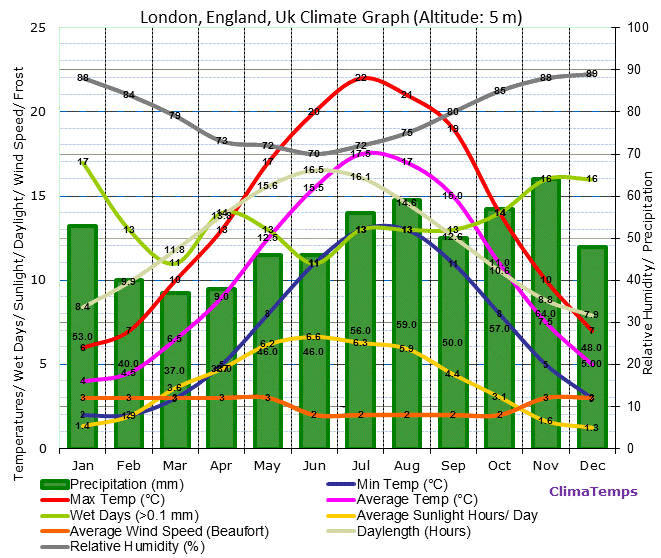

Figure.3. A left graph is a monthly climatic record of London; a right one is of Maseru. Monthly mean temperature is in pink line with highest in red and lowest in blue; rainfall in green column. Note that X-axis adopts different hydrological year, with London starting in January and Maseru in July. In addition, the primary Y-axis represents temperature (℃); the secondary in rainfall (mm)(Reference: Clima Temp, 2015 for London Clima Temp, 2015 for Maseru).
Another critical point to make about the basin's climate is that the evaporation rate is extremely high across the year with the mean annual rate of 1970mm/a, which exceeds the basin's MAR (Boroto and Gorgens, 1999). The implication is that the region is under severe water deficits in most of the time of the year, and perennial flow of rivers is pretty rare. It is estimated that due to extremely high intensity of sunlight and temperature, the African continent as a whole experiences very high evaporation/evapotranspiration rates up to 90% (Balek, 2011). All these meteorological factors being considered, Africa is characterized by regionally distinct climatic systems causing the uneven distribution of freshwater not only spatially but also temporally.
This nature of Africa's freshwater system has long been in central discussion in performing basin-based management because individual regions and countries perceive freshwater availability very differently. Nonetheless, with the emergence of inter-regional institutions for water resources management like the SADC mentioned earlier, I think that the situation is getting better. People from various backgrounds and social status are increasingly working together to deepen their understanding on the literature, management practices and so on. What now seems challenging to them is how to keep facilitating management while dealing with the intensifying effects of climate change and anticipated pressure on existing freshwater resources from the unprecedented rate of population growth. They cannot simply be given any clear answer by scientific research, rather, they have to make their own, responsible choice of what to do about it. Perhaps, this is a field where politics plays better than science. For any thoughts or questions, please share in comment! :)
No comments:
Post a Comment